
Detoured Infrastructure – The architecture of the National Tourist Routes
Valorizzazione del sistema viario Le caratteristiche del suolo norvegese sono, a dir poco, impegnative; il sistema viario del paese presenta un’infrastruttura fitta che permette di raggiungere tutti gli insediamenti. Il paesaggio norvegese ha un caratt …
Memorial of the victims of the witch trials
Zumthor’s memorial design is a simple gesture, a 400-foot-long memory hall framed by wood with sheets of silk suspended within — one window and one sheet per victim, all women who were burned to death — to create a soft, billowing, protective cocoon. M …

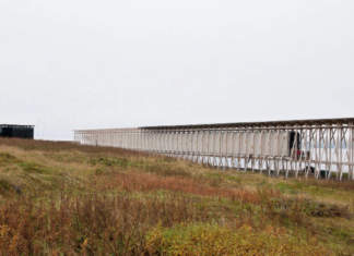
Viewpoint – bridge
The Bergsbotn-project is part of the Norwegian National tourist routes project; unique drives through the most spectacular countryside Norway has to offer. The National tourist routes are being developed and operated by the Norwegian Public Road Admini …
Barbeque, ramp and parking
The Tungeneset-project is part of the Norwegian National tourist routes project; unique drives through the most spectacular contryside Norway has to offer. The National tourist routes are being developed and operated by the Norwegian Public Road Admini …
eggum service building
Eggum is a community which lies on the seaward side of Vestvågøy in Lofoten. The former fishing village faces directly out to sea, on a small, level strip of land between steep cliffs and the sea. So is claimed to be the best place for such observation …

jektvik ferry quay
Despite the informal program the small service building on Jektvik ferry terminal the project is very much an experiment. Besides of meeting some very pragmatic functions – a waiting room and two rest rooms – the projects is first and foremost about tr …

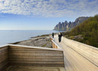
viewing platforms & bridges
The main platform is constructed by 25 mm laser cut steel sheets, cantilevered like a bridge around the cliff, hung in each end. The railing has a geometry that allows it to be continuous even with very different security requirements from place to pla …

Strømbu Service Centre and Rest Area
The 42 km Rondane Tourist Road goes on the east side of the Rondane Mountains from Enden in the south to Folldal in the north. The centre is situated near the midpoint of this route, and the place also serves as a main starting point for mountain hiker …

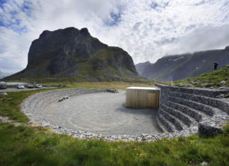
parking and small rest area
The project is a redesign of an existing parking. The existing parking was very primitive and it also created dangerous traffic situations. The cars are placed in a half circle. This allows the view to be enjoyed from inside the car in bad weather. The …
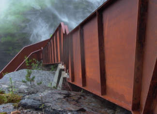
Svandalsfossen
The mighty Svandalsfossen waterfall lies on the National Route between Sauda and Ropeid, northwest of Saudafjord, at the innermost, northernmost head of the vast Ryfylke fjord system. The adjoining vista points and viewing platforms have been designed …