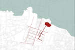
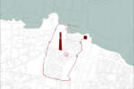
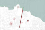
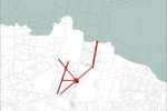
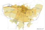
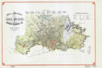
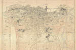
Beirut is the product of the superimposition of various settlement principles: Phoenician, Greek-Roman, Byzantine, Arab, Medieval, Ottoman and French. These are associated with different hidden alignments that have formed the evolution of its urban matrix over time.
This palimpsest is the result of overlaying over the past two millennia. At a certain level of its development the form of the city has assumed the radio-centric configuration characteristic of the Hausmannian city.
It has continued to change its appearance over the years, and with every destruction and reconstruction another veil concealing the city’s original appearance has been added; nevertheless, some traces are still evident throughout the city, such as the Roman Cardo and Decumanus that still dominate the urban arrangement as signs, stratifications and limits. Since the mid-nineteenth century, these axes were the backbone of the religious and educational centralities; they have in turn led to the creation of different peri-urban districts. Despite its rich Roman history, Beirut has never attained an important historical centre that has undergone a modern development, as in Tripoli or Damascus. Its medieval centre was destroyed in the Ottoman period and rebuilt in the period of the French mandate, without considering the relation between the old city centre and its surroundings, but only emphasising sea and land transportation.
The urban intervention of the French mandate period has been imposed on the original structure and has introduced “a planning strategy that follows a close hierarchy based on religious affiliation”. Between a planning strategy and the development of a settlement, the city has developed through the juxtaposition and superimposition of spaces, and its homogeneity is mainly confessional that constitute a circumscribed areas that interrupt the urban tissue. Over time, these areas have determined one of the principal characteristics of the urban form of Beirut: its “cluster structure”. This has resulted in an urban arrangement by parts or inward-looking sub-units, disconnected from one another as well as their surrounding urban tissue.
None of the town plans produced to date has managed to create osmosis between these areas and the rest of the city, starting with the Danger Plan.
The latter failed to create a balanced relationship between the religious sub-units on the one hand the different functional sectors on the other. It rather considered the peri-urban areas as autonomous villages, and its salient feature was the design of the major ring-road axes. The urban continuum has been disrupted by the infrastructural network, and fragmented by the cluster structure. The religious and educational centralities have been imposed as an assertion of the colonial domination and as the centres of specific sectors, referred to as mahallat. These establish spontaneous and implicit relations among themselves, culturally delimiting peri-central districts as Ashraffieh, Zokak el Blat, Basta, Ras Beirut and Hamra. Their strategic position within the urban and social tissue creates edges among the different components of the city; the Lazarian College in Ashraffieh or the large campus of the American University of Beirut (AUB) are two examples. The latter is a central and integral part of the development of Hamra, but at the same time it interrupts every relationship with the sea. These sectors or mahallats form the sub-units of the cluster structure; as separate entities within the city district, they become enclaves’ areas with isolated urban, social, educational and political development, introverting and limiting the functional aspects of urban portions.The most consistent process of transformation in the urban history of Beirut has begun with the Independence in 1943. Both Ecochard’s Plan and the modernization projects referred to as the “Shehabist reforms” are interventions on the transportation infrastructure level: alleys, straight thoroughfares, the shoreline, the expansion of the commercial harbour, the construction of the airport, the Charles Helou taxi and bus parking area and station8 along with the industrial areas. “Beirut is super-imposition, not superposition; it has a history of super-impositions: modernity on modernity”.
The new infrastructures represent yet another super-imposition and reinforce the cluster structure of the city: grafted onto the urban tissue through a demolition of whole slices of neighbourhoods, they make linear incisions disintegrating the ancient continuity, cutting the dense network of internal connections, consolidating “the separation between areas dominated by different confessional groups”10 and asserting the absolute supremacy of a viability logic based on a modernist matrix. The urban grid has remained indelibly scarred to this day. An example of this is Avenue Beshara El Khoury, which divides the districts of Mazraa and Ghobeiry into two.
In addition to emphasising the transportation infrastructure network, the SDRMB plan focused on the connection between the new centralities and the municipal city by means of a heavy, so-called ‘commuter-type’ infrastructure viability system.
The SDRMB11 plan moreover aims to create a green corridor, which regenerates the large isolated spaces along the whole former Demarcation Line. This dynamic green system would have reconnected all the areas populated by the different sects in the city: from the southern area by the airport to the Martyrs’ Square in the city centre, passing by important hybrid centres along the former demarcation line. This plan has unfortunately not been implemented, both due to the civil war and to the contingent socio-political configuration.Almost thirty years later the municipality is launching the challenge once again, and is restudying the system of green areas, beginning with the identification of a legislative instrument that allows the purchasing of land and buildings of strategic importance, such as buying Villa Barakat. This historical building, today called Beit Beirut, will become the museum of the city and its memory. While the urban vision of the municipality aims at a strategy of reconnection, the city centre in its present condition represents an entity disconnected from its surroundings. In the urban cluster structure of the capital, the centre constitutes the city’s largest sub-formation in terms of scale, while holding the richest historical heritage. It has also been subject of the greatest efforts in terms of town planning. This area, bordered by the infrastructure commercial ring-road to the south and by the sea to the north contains the history of Beirut from its foundation to present. Solidere, a private real estate company, has undertaken the reconstruction and planning since the 1990s. As in the case of the other sub-units or mahallat, the same peculiarities are encountered: a homogeneous fabric, an introverted configuration and disconnection with the surrounding urban tissue.
Also in this case, the sub-formation covering 184 hectares of land represents an element of profound interruption and disconnection of the urban tissue. But unlike other clusters, this one is characterized by considerable internal complexity due to the many layers and urban episodes that have shaped its character in the course of its history. Solidere’s recent projects have added another veil giving the cityscape of the centre a diffused uniformity. This prerogative is the resultant of a single private entity in charge of the management of such a complex and extensive plan.
However, what is happening on a large scale in the “Central District” is also happening on a smaller one in the whole city: the state has delegated the decision-making process related to the urban transformation to private entities, from architectural design to town planning, involving whole blocks, districts and vast urban areas as in the case of the city centre, but also in that of Haret Hreik, in the southern suburb of Beirut, the so-called Dahiye area, which was bombed during the war of 2006 and immediately rebuilt. “The city centre and Haret Hreik are quite comparable. Both projects are private initiatives, where the state has delegated decisions involving the future of the city to the private sector.”
The “central district” has eventually taken the form of an island of the formal urban tissue within a chaotic continuum characterized by a clear opposition between a planned city and urban chaos. The border between these two is formed by a ‘buffer zone’ that the municipality is currently working on in order to define a strategy shared with Solidere aimed at reintegrating the centre and its immediate surroundings. The plan considers three principal urban systems: the Fouad Shehab Ring Road around the centre, the aforementioned green corridor to be extended to Martyrs’ Square, and the first basin of what is today the touristic harbour. The failure to control the urban transformations has given rise to a disorderly and anarchic growth that is diffused on the entire territory.
One question remains open: whether it will be the planning instruments or the spontaneous dynamics of urban development that will eventually prove capable of assuring a satisfactory urban quality. Finally, the centre represents the part of the city that has been most carefully planned, as opposed to the surrounding tissue characterized by a progressive fragmentation and a vibrant diversity.
This for instance, is the case of Hamra, another sub-unit in the archipelago of a pluri-central Beirut which may be defined as an urban ecosystem characterized by a vibrant cultural, religious and political diversity. Ever since the fifties, this diversity has been associated with the presence of numerous movie theatres in this district: meeting places used by all members of the community without distinction as to faith. “I think that it is mainly Hamra that has been reborn as an alternative sub-centre, characterized by an interesting cultural and commercial mix, because I think the rest of Beirut has been gentrified. […] Solidere will be an important example for the other cities in the region. What to do and what not to do. It is like learning from Las Vegas...learning from Solidere.”
The city centre and Hamra offer an opportunity for reflection on the next evolution of the Lebanese capital. Will it be necessary to learn from Las Vegas or from Hamra in order to imagine the Beirut of the future?


