
For some time now Mexico City has existed in the global imaginary as one of the largest cities in the world; a paradigm of urbanization in the 20th century and more specifically of the developing world. This condition of being a developing mega-city. We usually tend to associate these particular traits to the condition of urbanity, but what I would like to argue in this short essay is that the single most important urban effect of Mexico City during the 20th century is not its urban centralities but rather its peripheries. From the most high-minded architectural efforts by architects such as Mario Pani and Luis Barragán, to the real dominant driving forces or urbanization today, -informality and large-scale developer-driven home building-, it has been the outsides what has produced Mexico City. These peripheries should not be seen in a derogatory way, but rather be understood as spaces that have evolved from being margins of the city, to places gaining depth, meaning and intensity in ways that we can consider a kind of emergent urbanity. In spite of being a fairly young city when compared to European cities, (it was founded in 1326 by the Aztecs), and in spite of having a complex combination of pre-Hispanic, colonial and modern histories, the history of Mexico City as we know it is really one that takes place in the 20th Century.
Between 1521 and 1900 the population and size of Mexico City barely grew in population, even losing considerable population during the 16th century due to epidemics. It has been only in the last 100 years, that population has increased from 300,000 inhabitants at the beginning of the 20th century to close to 20 million living in a surface larger than 1,400 square kilometers.
Mexico begins the 20th century in conflict: the Mexican Revolution (1910-1921) would serve as the ideological underpinning for a new relationship between culture and social transformation and it was only after 1921, that a stable condition be found for modern architecture and the city to flourish in Mexico. The 1930’s and 1940’s are decades of consolidation, and a time when the post-revolutionary regimes would begin to construct the new institutions of the city and the country. At the same time it is the first moment when the city begins to expand considerably, both as a result of new urban neighborhoods in the edges, as much as the departure of wealthier populations to the peripheral townships in the region. But it isn’t until the 1950’s when a combination of economic, political and demographic factors would create the boom for a new city. The sustained economic growth, industrialization and modernizing process made the city almost the single focus of the country. Fueled by both rural-urban migration and high-birth rates, this massive demographic growth became reflected in the built landscape of the city: in its infrastructure, as well as in its housing. Some of the most emblematic projects of mexican modern architecture such as the National University Campus and the housing projects by Mario Pani would take place at this time.
By 1950 the population of Mexico City had grown to 3.1 million inhabitants and the city extended over 250 square kilometers. This moment can be considered an urban threshold for many reasons: A transition from the post-revolutionary regime that dominated from the 1920’s to the late 1940’s, to a model where an intertwining between public and private investments would become the engine for growth and development in the city.
It is also the time where the City begins to expand beyond its own political limits, and by dynamics such as informal urbanization, a relevant point of inflection since it meant that architects and planners would lose their sense of agency in transforming and controlling the city. For the first time, the limits to urban growth began to inform the discourse and practices of planning.
In his 1950 film Los Olvidados, filmed and based in Mexico City, Luis Buñuel exposes the spiral of despair of extreme urban poverty in large (modern) cities, the tragedy of living in the slums, but most importantly, the difficulty of optimism and reform within the context of the modern project. Next to the construction sites of a modern city, Buñuel shows us the peripheries, where the real outsiders, the forgotten ones, are constructing their own city. At that time, Mexico City faced two radically different positions in relation to urban development: On the one hand, modern architecture and planning’s understanding of the city and its techniques to address and resolve the problems of housing, infrastructure and services. On the other hand however, the growing and pervasive reality of informal urbanization, as characterized by urban processes which take place outside the “legal”, planned and regulated modes of development of the city. Modern architecture and urban planning made of the peripheries their privileged geography: Some of the most emblematic planning and architectural projects of the time take place in the peripheries of the city. El Pedregal and the University City in the South and Ciudad Satelite in the north are the first ex-urban projects. Luis Barragan starts to develop El Pedregal de San Angel in the 1950’s as a site for large single-family residencies. The lava-covered environment of El Pedregal, ‘discovered’ as an aesthetic-fertile ground by artist Dr. Atl and later ‘developed’ by Barragán, facilitated a dramatic architecture, both residential and institutional, which produced an uncanny relationship with the ground and the landscape, as is the case of some of the buildings in Ciudad Universitaria, but probably more so in the houses by Francisco Artigas, Max Cetto and Barragan himself. Asides from the public gardens, fountains and small interventions by Barragan, the urban model of El Pedregal was somewhere in between the american suburb and a gated community. Lots larger than 1000 square meters for a single-family house and separated by walls from the street created a model detached from other forms of urbanity and land uses. The houses in El Pedregal rather than urban, represent a form of escape from the city.
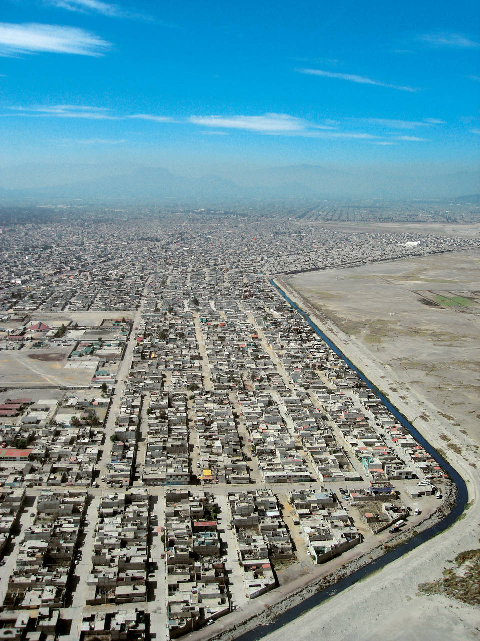
In a different fashion, the project to built the National University Campus in the outskirts of Mexico City can be seen as a move towards decentralization. Though less polemic, partially because of its condition as the most important site of Mexican modern architecture, the campus represented a critical step in the decay of the historic center of Mexico City. It is precisely with the departure by the academic community from the historic center, that population decline and loss of urban vitality took hold of the center. It is certainly paradoxical that the creation of this modern university city, had as an unintended consequence the loss of density and urbanity in the city proper. Meanwhile in the northern part of the city, for Ciudad Satelite, Mario Pani planned a modern middle-class suburb around the issue of mobility and the private car. A system of loops and districts, all leading back to a central artery structured a community planned for 200,000 inhabitants. Ciudad Satelite would represent the model of a new system of self-sufficient cities surrounding Mexico City. It was in the end the agenda of decentralization. The urban sculpture of the Towers of Satelite, done by Luis Barragan and Mathias Goeritz would serve as an icon or gate into this new community at the edge. In all these cases, there was a legitimate aspiration to connect territorial occupation with the social and economic realities facing the city at the time. From the 1950s but more notably during the 1960’s, the outskirts of Mexico City also began to be urbanized by a mode of urban production outside the legal, regulatory and professional frameworks and taking place through different forms of occupation such as squatting, illegal sales and subdivisions of underserviced land. This informal urbanization was the result of a huge demand for new land and housing by displaced inhabitants from central areas, as well as new migrants recently arriving from the country-side and from the disjointed urban policies implemented in Mexico City. Neza, short for Ciudad Nezahualcóyotl is without a doubt the most dramatic example of such an area. Located 12km east of downtown Mexico City on the dried Texcoco lake-bed, it was a site prone to flooding during the rainy season and to dust storms during the dry season.
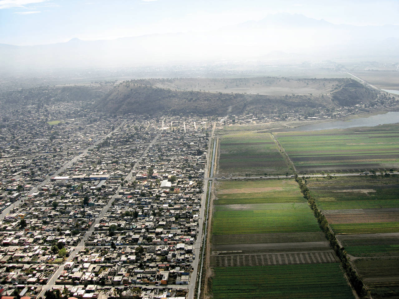
Neza developed through both illegal land subdivisions and sales by developers, as well as through invasions by squatters. These developers appropriated, sometimes buying, sometimes through other means, huge tracts of land on what used to be a lake, and most of them forfeited on their obligation to provide services and infrastructure. There was a tacit agreement that buyers of this ‘under-urbanized’ land, of dubious legality, would need to fight, negotiate and self manage, in order to achieve their progressive incorporation into an urban regime and satisfy their minimum living requirements. In less than 40 years, Neza made the jump from a desolate territory to a whole city of close to 1.5 million people. Currently Neza is a full-matured city with high degree of social interaction, plurality and spatial complexities that other ‘planned’ communities can only wish for. This model of urbanization became the norm during the 1960’s, 1970’s and 1980’s and extended to peripheries such as Ecatepec and Valle de Chalco to the southeast of the city and has created a continuous gray carpet of low-rise sprawl that extends to the horizon of the megacity and where the only markers have become the geographical accidents, the barren landscape or the large scale infrastructure that comes post de facto occupation. More recently we have seen a phenomenon that represents the next evolution of the peripheries characterized by the large scale transformation of rural tracts of land into developer-driven housing. In recent years, total annual housing production from the formal sector, both state and private developers, in Mexico City has been of over 105,000 units of housing a year. That number is still just barely over half of the total housing production since a similar number is provided yearly through the informal sector. What truly has been the difference in this recent model of urbanization, is the size and impact of some of the formal developments, all of them predominantly housing, privately developed with very little state intervention. The size of these developments is increasing as the ability to purchase land that was communally owned has allowed larger parcels to be put together and urbanized. Some of these planned neighborhoods have over 4,000 units of housing, and recently developments of up to 13,000 units of housing are being built by a single developer, and in many cases designed by a single architect.
These developments are becoming, by plan or by accident the largest gated communities in the city, where homogeneous streets, repetitive row houses and prevalent cul de sacs, become the privileged urban strategy. Planning is limited to the layout of a street grid, and the maximization of sellable land through the repetition of a very limited number of housing typologies. No zoning, no planning for educational, commercial or civic uses, very limited approaches to public space, no relation to metropolitan transport infrastructure, but most important, no room for growth and transformation in the neighborhood. Urbanity is collapsed to the simple construction of housing. What’s interesting to see as well is that these recent models of peripheries, both formal and formal, are happening side by side, exposing the limits of both modalities, but also their dialectical relationship: none are truly urban (yet), but both are constructing a new way to understand what we consider cityness. These peripheries expose the disjunctions between the architectural and the social, between the formal and the programmatic, between personal desires and profit-driven development, between normative urbanism and quotidian practices. And at the same time they have become the norm rather than the pathology: a way to imagine new forms of urbanity in the megacity.
José Castillo (Mexico City, 1969) is an architect and urban planner, living and working in Mexico City. He holds a degree in architecture from University Iberoamericana in Mexico City as well
a Masters in Architecture and a Doctor of Design degree from Harvard University’s Graduate School of Design. He founded the studio “arquitectura911sc” with Saidee Springall, in Mexico City.
His built works and writing have appeared in many international publications. He is professor at the Universidad Iberoamericana’s School of Architecture and U Penn’s School of Design. Since 2005 he curated various exhibitions about architecture and city.


