
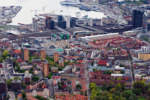
Backed by a strong municipal government and a network of equally wealthy and visionary investors, Oslo has in the last decade ventured on a project of territorial transformation of a range that is almost unique in the context of old Europe. Chiefly centred on the reconversion of vast industrial areas in disuse, the aim of the project is to reconnect fragments of the city that have been neglected for decades to the historical urban tissue through an articulated network of new programs and public spaces. A systematic mapping of the building sites that are currently open would show that they are extended over more or less the entire city, forming a topology of zones in the making of an extremely variegated nature, both in terms of scale and of the rapidity with which the changes are being implemented. But it is on the strip where the city meets the sea that most of the energies, physical no less than mediatic, have been concentrated. In line with a trend shared by many European cities, Oslo has for some years launched a process of relocation of the more central maritime infrastructures to peripheral sites, in order to reclaim large areas that have traditionally been dedicated to harbour activities in the urban territory, and thus open the city to the sea. The Oslo Fjordbyen project today covers an area of 225 hectares that embrace the ocean from west to east, subdivided in thirteen areas which are to be transformed in the near future, each of which has been attributed specific targets, schedules and players. However, there is a centre on which this future hinges. It is a matter of a vast area that until now has represented a hidden branch of the city, east of the centre, in an area between the railway station and the fjord. This is where most goods interchange activities, facilitated by the local convergence of important infrastructural lines, take place. Yet these self-same infrastructures have for decades kept this part of town irremediably separated both from the old town and the sea. However, the decision to move the industrial harbour out of town and to redirect the E18 motorway through a new tunnel under the sea, have made this area once again play crucial role in the development of Oslo.
The Bjørvika area is also part of the eastern half of the city, historically inhabited by lower classes, where all statistical data used to measure wealth have always registered negative data. It was inevitable that the transformation of the waterfront alongside this kind of context would also take on the significance of creating an opening to the sea for everyone. Thus, when the debates commenced as to where the first building of the future Fjordbyen was to be erected, the choice of moving the new Opera House from west to east immediately became token of a democratic promise shared by all parts.
Unchallenged milestone of the transformation of Bjørvika, the Opera House by Snøhetta has, ever since its opening in April 2008, become also an iconic reference for the entire Fjordbyen project. In fact, the large, snow-white surface in Carrara marble representing its roof seems to express in a nutshell, in an immense topography accessible to pedestrians, the essence of the project: the idea of relying on great cultural programs and the architectures housing them to produce a new urbanity and to characterize its public spaces. In line with this concept, another four large cultural institutions will in the next few years migrate from their old venues in the heart of the city towards the ocean. Fruits of as many architecture competitions, it is on these buildings that much of the debate on the architecture of Oslo centres today. It is a matter of the new Astrup Fearnley museum designed by Renzo Piano, the new Nasjonalgalleriet which will be erected on the by now cancelled traces of the old Oslo West railway station, the central Deichmann library, designed by Lund Hagem Arkitekter and Atelier Oslo, and the new Munchmuseet by Juan Herreros.
The disputes on the tectonic and spatial qualities of these projects are countless, and very often captious. But the debate on the waterfront of Oslo, today as in the past decades, truly seems to centre on rules and principles of its urban transformation. In fact, this debate commenced in the Eighties, when an industrial area in disuse, with an enviable location, was turned into a mix of luxury dwellings, offices, commercial offices and a sun-drenched seaside promenade, which is today internationally known as Aker Brygge. The immense success enjoyed by the transformation of Aker Brygge ever since its completion in 1989 has contributed, in the last twenty years, to the canonizing in the Norwegian context of a way to design the urban space, and the Fjordbyen project really seems to be the natural continuation, and to some extent conceptual improvement, of this approach. The model hinges on a strong public initiative, capable of defining and backing a complete and systematic transformation of whole parts of city and of involving private capital in order to realize these operations. The result is a vertiginous acceleration of the urban transformation process, which are in some cases completed in just one year, and the centralization of the design initiative in one or a few large architecture firms. The Tjuvholmen area, which is also a topographic appendix towards the sea of Aker Brygge, is perhaps the most recent, but also most literal translation of this model of built mass. In a not dissimilar manner the cartography of the new Bjørvika may be interpreted as the product of an alliance between public institutions committed to the definition of precise spatial and strategic planning principles, and investor groups – in this case all equally public – willing to bet on the success of these new territories and animated by a desire to consolidate their own presence in what will be the most important areas of the city of the future. However, there is a completely new concept in the dynamics of the present-day progress: urbanity and urbanism has become, also and chiefly, an architectural problem in Oslo It is on this point that much of the criticism of the Fjordbyen project has centred. One has for instance asked whether and to what extent the prioritizing of competitions, architecture and planning as a means of creating new urban space, rather dissimulates, in the context of a project that is almost entirely guided by public initiative, a symptom of a certain aphasia in the planning imagination of today’s town institutions. While, on the one hand, the Fjordbyen follows a tradition that is solid in the norwegian context, namely to conceive the development of the city in relation to landscape structures on a territorial scale, on the other the discussion as to what urbanity and what lifestyle one should propose in relation to the unique qualities of a front facing the fjord somehow seems to have been stranded on a rhetoric of an iconography framed by the ocean.But what is happening away from the Oslo waterfront? In a not too near future, proceeding eastwards from the Opera, one will encounter a new landscape of bridges, footbridges and small terraces on the water, as a result of a territorial plan which will bring the estuary of the river Akerselva, which has for decades been channelled below the docks, back to the surface. Akerselva is one of the most important structuring elements of the landscape of the Oslo area, the natural line which has historically separated the bourgeois city from the working-class neighbourhoods, on which the most important industries of the city had settled, exploiting the presence of the water. In the course of the years, ever since the years after World War II, the municipality of Oslo has dedicated itself to reacquiring the land along the river, in order to create leisure areas for the workers living in the area. Since 1992 this process has been consolidated in a systematic plan aimed at de-industrializing the river, and at reconnecting the remaining areas of nature in a linear green system of accessible spaces along its shores. Today Akerselva is a green infrastructure which crosses the city from its northern districts all the way to the fjord, at the same time ecological corridor and backbone of a mixed system of programs that combine advanced industries (media and IT), dwellings, cultural centres and educational institutions. For instance, an old power plant on the banks of Akerselva has become home to one of the two leading Norwegian architecture and design universities, AHO. The OCA – Office for Contemporary Art Norway and the DogA, Centre for Norwegian Design and Architecture, are mirrored by the river current just a few hundred meters to the south. The comparison with Bjørvika is inevitable. A walk along Akerselva today enables one to experience a part of the city which has taken the generative power of landscape logics seriously, where the river’s natural propensity to become infrastructure and a new fluvial ecology has become the foundations on which to build a new identity for the entire territory over time. It is certainly a matter of a less spectacular process than the one that is in progress on the ocean, but it may perhaps reveal a more interesting wager on the future of the city. It is here, between the polarity of these transformations, that the trajectory of the near future of Oslo may be read.

Alice Labadini lives and works in Oslo since 2008. She holds a degree in Architecture from Politecnico di Milano and is currently a PhD Research Fellow at AHO – Oslo School of Architecture and Design.
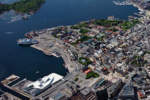
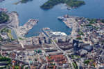
The photos accompanying the article are part of the “sett fra oven”, a study of Norwegian territory from the air born from a collaboration between the photographer Lasse Tur and the journalist Odd Helge Brugand. The images were taken during the spring 2010 from the point of view between 400 and 1300 meters high, on board a Cessna 172 piloted by Oddmar Stenhaug. The book “Oslo sett fra oven. En luftig ferd over hovedstaden“ collect a selection of 124 shots, short texts, historical and architectural report notes, or simply local stories. A book that is a unprecedented narrative of a journey through the capital, told by oblique perspective to the daily experience of the city.


